![](/images/other/stat-length.png)
![Excursión Senderismo Mont Lozère et Goulet - Stevenson 02 Mirandol (Chasseradès) - Les Alpiers - Photo](https://media.geolcdn.com/t/1900/400/ext.pjpeg?maxdim=2&url=https%3A%2F%2Fstatic1.geolcdn.com%2Fsiteimages%2Fupload%2Ffiles%2F1553511878bg_sport_marche.png)
Stevenson 02 Mirandol (Chasseradès) - Les Alpiers
motardes04
Usuario
![Longitud](/images/other/stat-length.png)
![Altitud máxima](https://static1.geolcdn.com/siteimages/upload/files/1508320355ic_sort_altitude_max_24dp.png)
![Desnivel positivo](https://static1.geolcdn.com/siteimages/upload/files/1508320355ic_sort_den_pos_24dp.png)
![Km-Effort](/images/other/stat-length.png)
![Altitud mínima](https://static1.geolcdn.com/siteimages/upload/files/1508320355ic_sort_altitude_min_24dp.png)
![Desnivel negativo](https://static1.geolcdn.com/siteimages/upload/files/1508320355ic_sort_den_neg_24dp.png)
![Boucle](https://static1.geolcdn.com/siteimages/upload/files/16400158638029165_repeat_loop_refresh_sync_direction_icon.png)
![Senderismo](https://static1.geolcdn.com/sitytour/trail-icons/101.png)
5h14
Dificultad : Muy fácil
![Escanee este código QR para abrir la excursión en la aplicación SityTrail](https://capi.geolives.com/qq0zvz2zws4bq2lad0pu/sitytour/trails/462032/qr.png?size=200)
Aplicación GPS de excursión GRATIS
A propósito
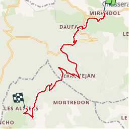
Ruta Senderismo de 15,8 km a descubrir en Occitania, Lozère, Mont Lozère et Goulet. Esta ruta ha sido propuesta por motardes04.
Descripción
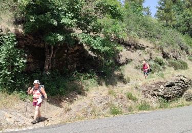
Temps de marche Marie 5h14.
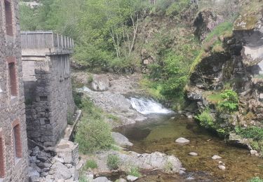
NB : j'ai fait le détour par les sources (pas inoubliables) du Lot et on s'est pris l'orage dans toute la redescente après la bifurcation vers les sources.
Calcul Sity Trail : 4h44 pour 15,8 km
Temps et distance topo depuis Chasseradès : 15 km - 4h30
Localización
Comentarios
Excursiones cerca
![Excursión Senderismo Mont Lozère et Goulet - 12-05-2023 E7 Bonnetés - Le Pont de Monvers - Photo](https://media.geolcdn.com/t/375/260/d16bfac8-7ce8-4044-a757-ffb026543eb4.jpg&format=jpg&maxdim=2)
![Senderismo Senderismo](https://static1.geolcdn.com/sitytour/trail-icons/101.png)
Senderismo
![](/images/other/stat-length.png)
![](https://static1.geolcdn.com/siteimages/upload/files/16400158638029165_repeat_loop_refresh_sync_direction_icon.png)
![Excursión Senderismo Mont Lozère et Goulet - Stevenson étape 7 - Photo](https://media.geolcdn.com/t/375/260/ca5e79f2-b988-472d-b1a4-865ced3314e1.jpg&format=jpg&maxdim=2)
![Senderismo Senderismo](https://static1.geolcdn.com/sitytour/trail-icons/101.png)
Senderismo
![](/images/other/stat-length.png)
![](https://static1.geolcdn.com/siteimages/upload/files/16400158638029165_repeat_loop_refresh_sync_direction_icon.png)
![Excursión Senderismo Mont Lozère et Goulet - Stevenson Chasseradès - Le Bleymard - Photo](https://media.geolcdn.com/t/375/260/084f4a90-f605-49e0-8cc1-95e8aee0296f.jpg&format=jpg&maxdim=2)
![Senderismo Senderismo](https://static1.geolcdn.com/sitytour/trail-icons/101.png)
Senderismo
![](/images/other/stat-length.png)
![](https://static1.geolcdn.com/siteimages/upload/files/16400158638029165_repeat_loop_refresh_sync_direction_icon.png)
![Excursión Senderismo Mont Lozère et Goulet - le Bleymard - Photo](https://media.geolcdn.com/t/375/260/a7e52d95-c918-4024-aa49-8bd4f60cbf65.jpg&format=jpg&maxdim=2)
![Senderismo Senderismo](https://static1.geolcdn.com/sitytour/trail-icons/101.png)
Senderismo
![](/images/other/stat-length.png)
![](https://static1.geolcdn.com/siteimages/upload/files/16400158638029165_repeat_loop_refresh_sync_direction_icon.png)
![Excursión Senderismo Mont Lozère et Goulet - Chasserades Bleymard - Photo](https://media.geolcdn.com/t/375/260/116a16c1-813e-45da-b910-05ff52927fe4.jpg&format=jpg&maxdim=2)
![Senderismo Senderismo](https://static1.geolcdn.com/sitytour/trail-icons/101.png)
Senderismo
![](/images/other/stat-length.png)
![](https://static1.geolcdn.com/siteimages/upload/files/16400158638029165_repeat_loop_refresh_sync_direction_icon.png)
![Excursión Senderismo Mont Lozère et Goulet - arsel chasserades au bleymard - Photo](https://media.geolcdn.com/t/375/260/93179cba-083a-4533-8ddb-80481acfe8eb.jpg&format=jpg&maxdim=2)
![Senderismo Senderismo](https://static1.geolcdn.com/sitytour/trail-icons/101.png)
Senderismo
![](/images/other/stat-length.png)
![](https://static1.geolcdn.com/siteimages/upload/files/16400158638029165_repeat_loop_refresh_sync_direction_icon.png)
![Excursión Bici de montaña Mont Lozère et Goulet - Chasserades Finiels 2020 - Photo](https://media.geolcdn.com/t/375/260/6b5f0140-2a52-469f-ac07-12640915fb18.jpg&format=jpg&maxdim=2)
![Bici de montaña Bici de montaña](https://static1.geolcdn.com/sitytour/trail-icons/202.png)
Bici de montaña
![](/images/other/stat-length.png)
![](https://static1.geolcdn.com/siteimages/upload/files/16400158638029165_repeat_loop_refresh_sync_direction_icon.png)
![Excursión Senderismo Mont Lozère et Goulet - Chasserades -Station Mont Lozère Stevenson - Photo](https://media.geolcdn.com/t/375/260/ext.jpg?maxdim=2&url=https%3A%2F%2Fservices.sitytrail.com%2FGeolivesWS%2FDownloadMedia.ashx%3FTrailID%3D769906%26Media%3Dfix__20170609174625.jpg)
![Senderismo Senderismo](https://static1.geolcdn.com/sitytour/trail-icons/101.png)
Senderismo
![](/images/other/stat-length.png)
![](https://static1.geolcdn.com/siteimages/upload/files/16400158638029165_repeat_loop_refresh_sync_direction_icon.png)
![Senderismo Senderismo](https://static1.geolcdn.com/sitytour/trail-icons/101.png)
Senderismo
![](/images/other/stat-length.png)
![](https://static1.geolcdn.com/siteimages/upload/files/16400158638029165_repeat_loop_refresh_sync_direction_icon.png)